

Webinars: „Advancing Frontiers of Geosciences“
International Webinar Series
The KIT international webinar series was established at the beginning of 2021 as an online program with the aim to provide individuals from the KIT Earth and space science community the opportunity to gain comprehensive knowledge on the latest advancements in geoscientific developments without the need of travelling in these uncertain times.
The webinar series will be dedicated to presentations and following discussions on new scientific ideas, exciting research projects, overviews of a geoscientific discipline, and new perspective in geosciences. Internationally acclaimed speakers will share their insights and latest research results. Speakers will be selected to present either disciplinary geoscientific topics or multi- and interdisciplinary topics across many geoscientific disciplines or even transdisciplinary topics across natural and social sciences, engineering, and policymaking. Webinars will also concern scientific challenges related to urgent problems of society, such as alternative sources of energy, environmental changes, and disaster risk reduction.
The webinars will be held monthly during semesters to attract attention KIT faculties, scientists, and students. Normally they will be scheduled on Thursday at 12:00 to 13:30, but the time may be adjusted to allow for speakers from Americas and Asia/Pacific.
The moderator of the webinar series is Dr. Alik Ismail-Zadeh.
Past Webinars
Artificial Water Reservoir Triggered Seismicity
Speaker: Harsh Gupta (India)
Date: 20 May 2021
Time: 12:00–13:30
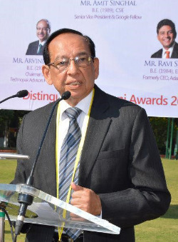
Abstract - Several anthropogenic activities such as gold and coal mining, filling of artificial water reservoirs, geothermal and oil/gas production, high-pressure fluid injection, etc. are known to have triggered earthquakes. Artificial water reservoir-triggered seismicity (RTS) is one of the most prominent among anthropogenic seismicity, with several hundred cases known globally. At least at 5 locations RTS events have exceeded magnitude M 6, causing much damage and claiming human lives. Koyna, India is a very prominent RTS site where earthquakes started soon after the impoundment of the reservoir in 1962, the largest RTS event of M 6.3 occurred on 10 December 1967, and RTS has continued till now (2021). Detailed investigation of RTS sequences has led to the identification of certain characteristics that are common to RTS earthquake sequences and differentiate them from normal (not associated with artificial water reservoirs) earthquakes. In the absence of near field studies, the mechanism of RTS is not well understood. Koyna is found to be a suitable site for such investigations. In collaboration with the International Continental Drilling Program, a 3 km deep Pilot Borehole has been drilled as a precursor to establishing a deep (6 to 7 km) borehole laboratory for the near field study of earthquakes. Salient features of these works are presented in this talk.
Harsh Gupta, Director Emeritus of the National Geophysical Research Institute in Hyderabad, India, is internationally known for his pioneering work devoted to characterizing earthquakes triggered by filling of artificial water reservoirs, discriminating them from normal earthquakes, and developing innovative mitigation procedures. Harsh Gupta has several major contributions on seismic and geodynamic processes at work in the Tibetan Plateau and Himalayan regions, the Bay of Bengal, and the Arabian Sea, as well as on characterization of seismic rupture zones of the Koyna and Latur stable continental regions. Harsh Gupta published over 200 scientific papers and several authored and edited books. Harsh Gupta received several awards, prizes and medals including Waldo E. Smith Medal of the American Geophysical Union and Shanti Swarup Bhatnagar Prize for Science and Technology (India). He is a Fellow of the National Academy of Sciences of India and the Indian National Science Academy. He is currently a Member of the Indian Atomic Energy Regulatory Board, President of the Geological Society of India, and the Editor-in-Chief of the Encyclopedia of Solid Earth Geophysics (Springer). He was a Member of the Indian National Disaster Management Authority chaired by the Indian Prime Minister; Secretary to Government of India, Department of Ocean Development; Vice-Chancellor, Cochin University of Science & Technology; and Professor of the University of Texas at Dallas (USA). He served the International Union of Geodesy and Geophysics as President for 2011–2015.
Compound and Cascading Hazards:
Typology, Modeling and Risk Assessment
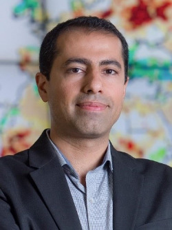
Speaker: Amir AghaKouchak (USA)
Date: 24 June 2021
Time: 9:00–10:30 (note the time!)
Ground-based observations and model simulations show substantial increases in extreme events including rainfall events, droughts, wildfires, hot spells and heatwaves. The first step toward improving our societal resilience is to identify the new patterns of climate extremes and natural hazards. This requires a better understanding of tempo-spatial characteristics of natural hazards and also the interactions between different hazards in a changing climate. A combination of climate events (e.g. high temperatures and high humidity, or low precipitation and high temperatures) may cause a significant impact on the ecosystem and society, although individual events involved may not be severe extremes themselves – a notion known as compound event (e.g. extreme rain over burned areas, combined ocean and terrestrial flooding). Numerous studies have focused on how different types of extremes have changed or might change in the future. However, very few studies have investigated the changing risk of compound and cascading events. This presentation focuses on three different types of compound and cascading events including drought-heatwaves, sea level rise-terrestrial flooding and meteorological-anthropogenic drought. We present different methodological frameworks and perspectives for detecting, modeling and risk assessment of compound and cascading events.
Amir AghaKouchak, Professor of Civil Engineering, Environmental Engineering, and Earth System Science at University of California, Irvine, USA, is among the most creative and productive mid-career geoscientists, and his scholarship, international standing, outreach and service to the community are widely acknowledged. Amir AghaKouchak has published over 170 research papers focusing on hydrology, remote sensing, civil and environmental engineering, water resources, natural hazards, climate change, climate extremes, droughts, floods and compound hazards. He is known for his contributions to analysis and understanding of natural hazards and their societal impacts, including droughts, floods, heat waves and the interactions between inter-related compounds. Amir AghaKouchak is a Fellow of the American Geophysical Union and received several awards and medals including the 2012 Frontiers of Engineering Education Award of the U.S. National Academy of Engineering; the Hydrologic Sciences Early Career Award of the American Geophysical Union (AGU); Early Career Scientist Award of the International Union of Geodesy and Geophysics; AGU James B. Macelwane Medal (for his fundamental and innovative contributions to the study of hydrologic extremes and compound natural hazards) and Walter L. Huber Civil Engineering Research Prize of the American Society of Civil Engineers (for his notable contributions to the science of compound and inter-connected extreme weather events). Currently, Amir AghaKouchak is the Editor-in-Chief of the AGU Earth’s Future journal. Website: http://amir.eng.uci.edu/
Long-term Strength of the Lithosphere and the Distribution of Seismicity
Insights from 3D-Observation-based Models
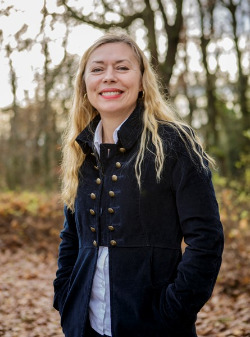
Speaker: Magdalena Scheck-Wenderoth (Germany)
Date: 22 July 2021
Time: 12:00–13:30
Integrating observations on the physical configuration of the lithosphere into data-based 3D structural models resolving the first order variations in physical properties is still a major challenge in geosciences. Nevertheless, such integration yields results that improve with the amount and variety of data types integrated. We use 3D models that integrate surface geology, well informations, seismic and seismological observations as well as gravity and heat flow observations to resolve the first order characteristics of the present-day physical state of the sedimentary part, the crystalline crust and the uppermost mantle in different tectonic settings. We then use these 3D geological models as a basis to calculate the thermal and rheological configuration that together describe the present-day thermomechanical stability of a certain setting. Next, we assess how the lithospheric strength varies within the region in response to the natural tectonic setting as well as the internal thermal configuration, and how those variations can be related to the recorded seismicity. The results from different studies indicate that the regional characteristics of the long-term strength of the lithosphere match the spatial distribution of seismicity, indicating that the mechanical stability of an area is primarily controlled by strength variations. Comparing the modeled strength distribution with available seismicity catalogs, we find that seismicity is shallower and of lower intensity due to a hotter and weaker crust of more felsic composition compared to seismic energy release of larger magnitudes occurring at deeper levels in more mafic crustal domains. We compare the rift setting of the Rhine Graben with the Alps and their forelands as well as with the transform setting of the North Anatolian fault system in the Marmara Sea. The work to be presented here has been conducted in collaboration with M. Cacace, D. Anikiev, J. Bott, E. Golamrhezaie, C. Spooner, H.J. Götze, and M. L. Gomez Dacal.
Magdalena Scheck-Wenderoth is the Director of Department „Geosystems“ at GFZ Potsdam, head of Section Basin modelling at GFZ Potsdam, and Professor for Basin Analysis at RWTH Aachen University, Faculty of Georesources and Materials Engineering. Magdalena Scheck-Wenderoth’s research interests are broad covering geodynamics, sedimentary basins evolution, geoenergy, simulation of coupled thermal-hydraulic-mechanical processes, thermal field, the lithosphere structure, gravity and isostasy and interpretation of seismic data. Magdalena Scheck-Wenderoth published more than 100 peer-reviewed papers and book chapters. Magdalena Scheck-Wenderoth is a Member of Academia Europaea. She serves DGGV German Geological Society as Vice President and the Nationale Begleitgremium (NBG) as a Member elected by the German Government. She was Secretary General of the International Lithosphere Programme, co-sponsored by the International Union of Geological Sciences and the International Union of Geodesy and Geophysics.
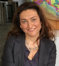
International Geoscience Programme Enabling Early Career
Geoscientists to Achieve Sustainable Development Goals
Date: 7 October 2021 (POSTPONED)
New Date: 4 November 2021
Time: 12:00–13:30
Özlem Adiyaman Lopes is Senior Adviser to the International Geoscience Programme of UNESCO. She holds a Ph.D. degree, from the Paris Sorbonne University (France) in partnership with the Hacettepe University (Ankara, Turkey) and Blaise Pascal University (Clermont Ferrand, France); she has scientific research expertise in the fields of Earth Observation data processing and interpretation as well as Structural geological and Geochemical analysis of the active tectonic and volcanic zones. With her over 20 years professional experience in the corporate and public organisations as well as academic sector (i.e. Portsmouth University and Imperial College of London, ConocoPhillips Inc. USA and Department for Education and Department for Business and Innovation in England), Dr. Adiyaman is specialized in geosciences communication, natural resources exploration, supplier/contract/programme management for the development and dissemination of new technical and scientific products and technology transfer. Following the completion of her PhD in 2000, Özlem lectured at the Geohazards Research Centre of Portsmouth University and worked with Conoco Phillips Inc. in Houston as an exploration geologist. During her service for the Ministry of Education between 2004 and 2011, she established and delivered new change programmes in England to design and distribute the national exams and modernize this process by implementing strategic technical changes necessary. At Imperial College of London, she led grant proposal development activities and upon successfully receiving multimillion £ EPSRC Programme Grant, she directed a team of cross-divisional scientists from several major UK and International Universities and industry (Airbus, EADS, NASA Langley) to deliver a science programme to produce new and accurate approaches to predicting and controlling transition to turbulence (Laminar Flow Control). Between 2013 and 2016, Özlem led New Products Development team at the National Physical Laboratory and delivered £6M/year Research and Innovation government contracts to ensure the launch of NPL’s new propositions into the market is in conjunction with fully developed solutions as well as internal business readiness. Since 2016, Özlem works for the UNESCO Natural Sciences Sector and is responsible for the implementation of the international collaboration projects and global initiatives related to the International Geoscience and Geoparks Programme (IGGP).
High-Pressure Fe-O-H Chemistry and Earth Oxygen Cycle
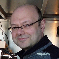
Date: 16 December 2021
Time: 12:00–13:30
Abstract - Iron oxides and oxyhydroxides are major phases among oxidized iron species, commonly called rust, which can be formed in many ways including as a byproduct of anoxygenic prokaryote metabolism that took place from about 3.8 billion years (Ga) ago until the Great Oxidation Event (GOE) roughly 2.2 Ga ago. Rust was buried on the ocean floor and was transported into the mantle as a consequence of plate tectonics that started at least 2.8 Ga ago. The fate and the geological role of rust at pressure and temperature conditions of the lower mantle have been unknown up to now. We studied the behavior of different compounds in Fe-O-H system in 100 GPa pressure range and temperatures over 2500 K using in situ synchrotron single-crystal X-ray diffraction and other complementary techniques. At conditions that correspond to the coldest slabs at depths of about 1000 km we observed formation from rust of numerous iron oxides (Fe2O3, Fe5O7, Fe7O10, Fe6.32O9) and an oxygen-rich fluid. Our results suggest that recycling of rust in Earth’s mantle could contribute to redox conditions of the Earth interiors.
Leonid Dubrovinsky is Director of Research, Professor at the Bavarian Research Institute of Experimental Geochemistry and Geophysics (Bayerisches Geoinstitut, University of Bayreuth, Germany). His main areas of interest are high-pressure mineral physics and geochemistry, development of methods of static ultra-high pressure generation, synthesis and studying of properties of novel materials, application of synchrotron radiation in materials and geosciences, and development of instruments and sample environment at X-ray synchrotron radiation facilities. The methodology of single-crystal X-ray diffraction studies in laser-heated diamond anvil cells at multimegabar pressures, developed by Leonid Dubrovinsky and Natalia Dubrovinskaia, enabled quantitative investigations of chemical processes and structural modifications at conditions of planetary interiors. Leonid Dubrovinsky authored and co-authored more than 490 peer-reviewed papers in various areas of geo- and materials sciences, crystallography, solid state physics and chemistry, and high pressure technology. His contribution to science has been recognized with several awards including the Medal of the European Mineralogical Union and the Gregori Aminoff Prize in Crystallography of the Royal Swedish Academy of Sciences.
A World of Karst and Caves
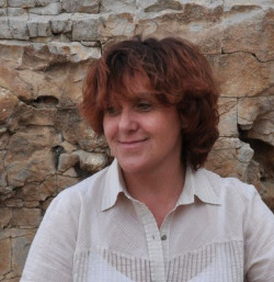
Speaker: Nadja Zupan Hajna (Slovenia)
Date: 20 January 2022
Time: 12:00–13:30
Abstract: As often hidden features and landscapes, caves and karst are generally poorly understood and recognized. Basic scientific studies can serve as a basis for protection, sustainable management, and more effective responses to pollution events. Karst is a special type of landscape with distinctive surface, hydrological and underground features, formed by dissolution processes in soluble rocks such as limestone, gypsum and salt. Caves also exist in non-karst rocks, particularly lava caves and caves in coastal settings. Karst landscapes occupy about 20% of the surface of the continents, but because they have evolved in different geological and climatological environments, there are many varieties of karst landscapes worldwide. Various forms exist on the karst surface, ranging from small karren to large collapse dolines and poljes. Caves are underground cavities large enough for humans to enter. Caves can vary in shape, origin, and development. The karst surface is rocky, usually without a thick soil cover, and there is usually no water on the surface. Throughout history, karst has never been densely populated due to the lack of water and soil. Larger settlements were located near karst springs or caves with water. With a growing population, karst landscapes are inhabited by about 1.2 billion people. As karst areas become densely populated, people begin to encroach on them, altering and polluting them. The most common threats to karst underground, waters, caves, and specialized subterranean fauna are urbanization and industry, agriculture, logging, quarrying, water exploitation, excessive groundwater pumping, tourism, and recreational activities. The distribution of karst all over the world, in different rocks, climatic conditions, its characteristics, peculiarities and its high vulnerability due to a thin soil layer and rapid water flow through crevices enlarged by corrosion and open channels where pollutants can move very quickly towards the springs, pose challenges to karst from different perspectives. Karst science, which is highly interdisciplinary, studies various aspects of the different challenges and their solutions, including karst geology, geomorphology and speleogenesis, karst hydrogeology, speleobiology and microbiology, karst modeling, karst hazards and management, and climate changes and, more recently, extraterrestrial caves. Scientific studies of karst and caves use new technologies to obtain new results using advanced methods. The goal is to collect new data and digitize old ones, as well as create databases for future work and open public access. Because the karst terrain is subject to chemical and mechanical erosion/denudation, correlate sediments are absent from the surface. The karst system effectively transports surface sediments through the karst porosity and accumulates them in caves. Here, sediments are better protected than at the surface and show a good preservation form even after a long time of deposition in cave systems. Therefore, cave sediments show an exceptionally good multi-proxy record (obtained by U/Th and 14C dating, paleomagnetic analysis of speleothems and sediment profiles, cosmogenic dating of quartz pebbles, stable isotope analyzes, paleontology, sedimentology) of external environmental conditions, tectonic trends, and other processes at the time of their deposition. For instance, the studied cave sediment sequences could well represent chronostratigraphy, climate and tectonic evolution from the Mio/Pliocene to the Holocene. However, if we know the changing trends, we can surmise their patterns in future events.
Professor Nadja Zupan Hajna is a Research Advisor at the Karst Research Institute of the Scientific Research Centre of Slovenian Academy of Sciences and Arts, Professor at the UNESCO Chair of Karst Education of the University of Nova Gorica and the Karst Research Institute, and Officer/Treasurer of International Union of Speleology. She is mainly engaged in the studies of cave sediments, karst geomorphology and geology, as well as the interpretation and promotion of karst and its science.
Physico-Mathematical Modeling of Explosive Eruption Dynamics
and Hazards: Some Recent Achievements and Perspectives
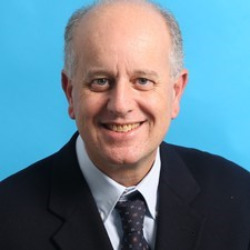
Speaker: Augusto NERI (Italy)
Date: 17 February 2022
Time:12:00–13:30
Abstract: About 10% of the world's population live within 100 km of an historically-active volcano, and the potential for great loss of life and economic disruption in violent eruptions has emerged as a major problem. Developing the capacities to better understand volcano dynamics and to forecast and mitigate hazards are therefore principal scientific priorities. Nevertheless, understanding of explosive eruption dynamics and assessment of their hazards continue to represent challenging issues to the present-day volcanology community. This is mostly due to the complex and diverse nature of the phenomena as well as to the unpredictability and non-reproducibility of volcanic processes. This presentation gives an overview of some contributions to these challenging objectives arising in the last decades from the development, improvement, and application of physical-mathematical models. In particular, transient, 2D/3D, and multiphase (particles plus gas) flow models were developed implementing state-of-the-art formulations of the physics with high-performance computational techniques. Numerical simulations produced by such codes have allowed to better understand and fairly accurately reproduce well-documented volcanic events, and provide key insights in comprehending the complex and often non-intuitive dynamics of explosive eruptions - such as convective plumes, collapsing columns, pyroclastic density currents, short-lived explosions, ash dispersal and deposition, etc. 3D modeling with DEM topography is also a powerful tool in quantifying and communicating potential eruptive scenarios and associated hazards. Simplified models based on a reduction of the system complexity have been also proved useful, combined with Monte Carlo and statistical methods, to generate quantitative probabilistic hazard maps at different space and time scales, some including the quantification of some sources of uncertainty. In the presentation, I will illustrate selected modeling approaches, and describe numerical simulations of explosive phenomena specifically developed to quantify hazard at certain high-risk volcanoes such as Vesuvio and Campi Flegrei (Italy). I conclude by reporting on future challenges and key next steps to further progress modeling research and its contributions to the mitigation of volcanic risk.
Augusto Neri is the Director of the Volcanoes Department of Instituto Nazionale di Geofisica e Vulcanologia (INGV), Italy. Dr. Neri received his MSc from the University of Pisa (Italy) and his PhD from the Illinois Institute of Technology, Chicago (USA). Since 2003 Augusto Neri is Research Director in physics of volcanism at INGV. His scientific career has been focused on the development and application of multiphase flow models of explosive volcanic processes and phenomena, particularly collapsing columns, pyroclastic density currents, volcanic plumes, ash dispersal and deposition and conduit flow. Several complex and non-intuitive processes were highlighted through these models, which brought to a more robust understanding of the dynamics of explosive eruptions. For instance, the application of these models to well-observed events, such as the 18 May 1980 Mt. St. Helens volcanic blast and the 1997 Vulcanian explosions of Soufriere Hills volcano, Montserrat, allowed to better elucidate the internal dynamics of these phenomena. Augusto Neri has also contributed to the quantitative assessment of volcanic hazards at Italian and foreign volcanoes such as Vesuvio, Campi Flegrei, Etna, Stromboli, Mt. St. Helens, Soufriere Hills of Montserrat, La Soufriere of Guadeloupe, Santorini, etc. He is author of more than 100 scientific papers and has been the principal investigators of many international and national projects in the relevant fields. His research was also recognized by the coordination of the successful EU-funded EXPLORIS project. Augusto Neri has been awarded the Sergey Soloviev Medal of the European Geosciences Union (EGU) for his outstanding contribution to natural hazard research. He is an Honorary Fellow of the Geological Society of America (GSA) and Fellow of the American Geophysical Union (AGU).